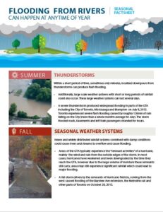
In July and August of 2024, Mississauga faced an unprecedented rainstorm, with the city receiving more rainfall in a short period than ever before. I know such storms can bring significant stress and inconvenience, impacting our homes, properties, and lives.
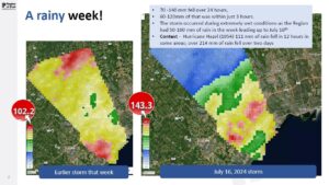
From August 17 to 18, our city saw varying amounts of rainfall from 6.2 mm up to as much as 170 mm in some areas – leading to high water levels and major disruptions on roads, creeks, and highways. This only serves to show the unpredictability of these types of storms and range of impacts our city can see.
This is what’s called a “100-year storm”. Unfortunately, we had another 100-year storm on July 16th and many will recall the storm in July 2013, as well.
We are taking stormwater management seriously. In 2024, we have allocated $33.7 million for stormwater improvements, focusing on projects along Cooksville Creek, Etobicoke Creek, and erosion control initiatives. Since 2016, we have invested over $231.5 million in stormwater infrastructure. Our 10-year plan includes an additional $340 million for ongoing upgrades and maintenance to enhance our resilience against future storms. And, we remain committed to continued investments in further enhancing our stormwater infrastructure to withstand future weather events like this one. These investments include stormwater ponds, new pipes in the ground, and repairs to creek and river banks to prevent erosion.
As an example, Lake Saigon – a critical stormwater management facility in the City’s system within the Cooksville Creek watershed, held back 250,000m3 of stormwater, and therefore and therefore reduced the risk of flooding downstream. This one pond held back the equivalent of 100 Olympic-sized swimming pools of water from flowing downstream to homes and businesses.
As Ward Councillor, I am working closely with my colleagues to urge the province to activate the Disaster Recovery Assistance for Ontarians (DRAO) program.
We are asking those whose property was impacted by the recent rain event this weekend, to please contact 311 to provide your name and address. This information will be shared with the Government of Ontario to support our efforts in urging them to activate their DRAO program for Mississauga.
Additionally, please be sure to document any damage with photos or videos and inform your insurance provider as soon as possible.
City cleanup efforts are underway, including debris removal and park restorations. We understand how challenging this situation is and truly appreciate your patience as we work with local and regional partners to address repairs and assess the damage.
We remain committed to supporting our community during this difficult time and will continue to invest in improving our stormwater infrastructure.
For more information, please visit our website at mississauga.ca.
Mississauga crews continue clean up after the weekend storm
Clean-up efforts continue, including the removal of debris from sidewalks, roads and trails.
This past weekend, Mississauga experienced another severe rainstorm which resulted in a large amount of heavy rain within a short period of time. From August 17 to 18, rainfall amounts varied across Mississauga with some areas of the city seeing as little as 6.2 mm and the hardest hit areas receiving 170 mm. Heavy rainfall caused high water levels and localized flooding on roads, along creeks, rivers and streams.
Some areas near Dixie Rd. and Dundas St., Cooksville Creek, Streetsville, Malton, Lisgar, highway stretches of the 401, 403 and 410, and the Airport were heavily impacted. From road closures and increased traffic, the effects were felt widely across the city.
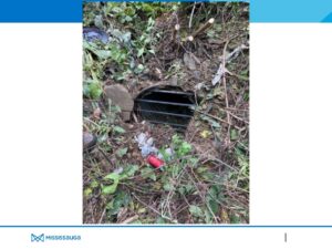
Experts in meteorology, climate change and environmental science are pointing to these events as evidence of how global warming is changing our weather patterns, suggesting such storms could become a common occurrence.
Residents are reminded to take precautions in flooded areas and to respect all posted signs, and barricades that have been put up for safety reasons.
Mississauga’s stormwater system
While some parks and roads flooded, and trails experienced erosion, some residents faced property damage, basement flooding or water pooling in their backyards. Without the City’s stormwater infrastructure being in place and staff actively managing the situation, the situation could have become much worse.
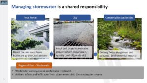
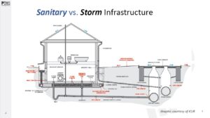
Separate from the sanitary wastewater system, the City’s stormwater system collects stormwater from properties and carries it to a receiving waterbody. Maintaining this system lessens the risk of flooding, reduces creek erosion and protects water quality.
Currently, Mississauga has more than 1,900 kilometres of storm sewer pipes in its drainage system. If laid out end-to-end, these pipes would connect Mississauga to Winnipeg. The stormwater drainage system also includes more than 51,000 catchbasins, 270 kilometres of ditches, 150 kilometres of creeks and 81 stormwater management facilities (including ponds, underground storage and Low-Impact Development facilities) that help collect, drain and clean the City’s rainwater runoff before it enters Lake Ontario – the source of our drinking water.
In 2024, we have allocated $33.7 million for stormwater improvements, focusing on projects along Cooksville Creek, Etobicoke Creek, and erosion control initiatives. Since 2016, we have invested over $231.5 million in stormwater infrastructure. Our 10-year plan includes an additional $340 million for ongoing upgrades and maintenance to enhance our resilience against future storms. And, we remain committed to continued investments in further enhancing our stormwater infrastructure to withstand future weather events like this one. These investments include stormwater ponds, new pipes in the ground, and repairs to creek and river banks to prevent erosion.
The need for continued infrastructure funding
Over the next 10 years, the City’s Stormwater Program will continue to expand and be maintained, in order for our stormwater system to remain fully funded – due to the stormwater charge. However, there is still a need to appropriately contribute to the Pipe Reserve Fund to allow for the future replacement of the City’s aging stormwater pipes.
The City is seeking a commitment from federal and provincial governments and is advocating for additional funding to help bridge the infrastructure gap. This is crucial for underlining priorities, such as stormwater infrastructure, that are vital to the safety of our community.
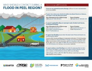
Flooding on your property
If your home or basement has flooded and you’re in immediate danger or require assistance, call 911.
- If you’ve suffered damages due to a basement flood, call 311. The City creates a record documenting these type of calls.
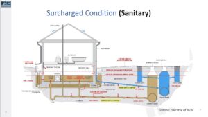
- If you think there’s a problem with your sanitary sewer pipe, you can request emergency help with a sewer backup.
- Record the details of the flood damage by taking photos or videos. Register the amount of damage to your home with your insurance provider immediately.
- Don’t attempt to shut off electricity if any water is present. Leave your home immediately and don’t return until authorities confirm it’s safe to do so.
- After you have evacuated your home or if water has risen above your electrical outlets, baseboards or furnace, call Alectra at 1-833-253-2872 to report it.
Clean up continues
Clean-up efforts continue, including the removal of debris from sidewalks, roads and trails. The City is still assessing the financial impacts to the Corporation and is working alongside its local and Regional partners, like the Region of Peel and Credit Valley Conservation, to collect data and insights about the severity of this weekend’s flooding.
Parks and trail closures
Residents are asked to take precautions in flooded areas and respect all posted signs and barricades that have been put up for safety reasons. Residents are asked to use caution in all parks and trails, creeks, rivers or watersheds.
Sportfields
Most sportfields have been able to re-open across Mssissauga with the exception of the following:
- Courtney Park Cricket Pitch
- All fields at Meadowvale Sports Park (Major Soccer, Major Baseball, both Major Softball)
- Lisgar Fields Major Baseball Field
- Dunton Fields, Major Softball Fields 1&2
- All secondary fields in the Malton area
- Quenippenon Major Baseball Field
MiWay
MiWay all routes are operating in normal condition.
To assist City crews effectively during this period, please consider the following guidelines:
- Use extra caution when navigating near areas where construction or maintenance activities are taking place.
- Follow all posted signage and barriers around work sites, showing respect for the guidelines in place.
- Make sure to give workers and their equipment the necessary space to safely conduct their tasks.
- Practice patience and kindness towards the crews as they work to repair and restore essential services and infrastructure.
Additional information about flooding:
- Residential guide to flood prevention
- Essential outdoor cleaning tips to prevent flooding, pooling and pollution
- How to prepare your home for basement flooding
- The Institute for Catastrophic Loss Reduction (ICLR) handbook for reducing basement flooding
- Insurance experts provide guidance to Ontario residents in wake of flash flooding
- Flooding and Insurance
Stormwater investments
|
Stormwater Infrastructure Investment: |
||
| City Wide | Notable Projects | |
| Spent to Date (2016-23) |
$ 92.7 M | – Lake Saigon SWMF
– Cooksville Underground Storage Facilities – Lisgar Pumping Station |
| Works In-progress (2016-23) | $ 105.0 M | – Dixie-Dundas Flood Mitigation Design
– Little Etobicoke Creek Drainage Improvements – Malton Drainage Improvements |
| Budgeted (2024) | $ 33.7 M | |
| Total | $ 231.5 M | |
Note: values shown are since the Stormwater Charge was established (2016).
2024 Capital Funded projects
Approved 2024 projects funded at $33.7 million, which include:
- Mississauga LRT Storm Sewer Improvements
- Malton Drainage Improvements – Etude Dr. to Justine Dr.
- Design for Dixie Dundas Drainage Improvements by Little Etobicoke Creek
2024 Planned construction projects: Creek, erosion control work and stormwater management facility projects
- Construction of a pumping station at the south-east corner of Doug Leavens Blvd and the Lisgar channel
- Etobicoke Creek erosion control and rehabilitation (Ponytrail Dr. to Bloor St.)
- Sawmill Creek erosion control and rehabilitation (Folkway Drive to Erin Mills Parkway)
- McKenzie Park Storm Water Management Facility
- Sheridan Creek erosion control and rehabilitation (Lushes Avenue to behind Fletchers Valley Crescent)
- Cooksville Creek improvement and flood protection and replacement of King Street Bridge
- Dredging and rehabilitation of Dixie Road Bus Rapid Transit pond
- Dredging and rehabilitation of Tomken Road Bus Rapid Transit pond
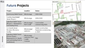
10 -Year Capital Plan
2024–2033 projects to be funded at $340 million and include:
- Design and Construction of Pond Dredging and Rehabilitation at Lake Wabukayne & Aquitaine (2025)
- Malton Flood Relief Project (Etude Dr. to Justine Dr.), including construction of a stormwater box culvert beneath the pedestrian walkway, full reconstruction of the walkway to safely create an overland flow route, and an upgraded outfall structure and channel in Derry Greenway Park (2025 – TBD)
- Dundas & Lakeshore BRT Storm Sewer Improvements (2025)
- Design and Construction of Cooksville Flood Storage Facility – Greyshale Park (2027) and Heritage Hills Park (2028–2030)
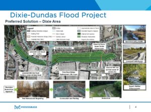
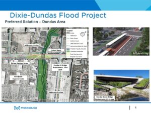
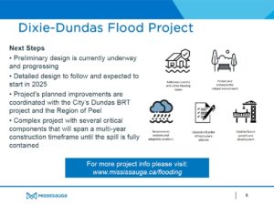
- Dixie and Dundas Drainage Improvements (2025, 2027–2033)
- Construction of Sawmill Creek Erosion Control–Erin Mills Parkway to The Collegeway (2029)
2024-2027 Business Plan and the 2024 Budget for Stormwater
Why is the City experiencing this level of flooding?
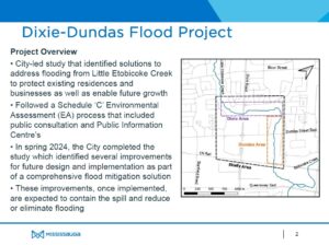
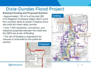
During severe storm events, like those experienced recently, the City’s stormwater system, as well as other municipalities in Ontario, will exceed its design capacity. The City’s underground storm sewer system is designed to a 1 in 10 year event capacity. Once that capacity is reached, excess flows are then conveyed along the roadway or another overland flow route to a creek or other body of water. However, the recent rainfall events exceeded the design capacity of the overland flow system. The City continues to invest in stormwater management improvements throughout the City such as Lake Saigon along with underground storage facilities in the Cooksville Creek watershed, the City’s largest watershed, to reduce the risk of flooding. Also, the City is currently undertaking design to address a spill point on Little Etobicoke Creek where flows can onto Queen Frederica. This project can be found at https://www.mississauga.ca/projects-and-strategies/environmental-assessments/dixie-dundas-flood-mitigation-study/
How has the build-out of the City contributed to this?
The urbanization of Mississauga is similar to other North American cities. A consequence of which is the hardening of lands due to development. The development of the City to accommodate population growth is based on planning policies and the City’s stormwater infrastructure is designed and constructed in accordance with accepted industry engineering standards of the day.
What actions has the City taken to date to respond to the changing climate?
The Build Beautiful Stormwater Master Plan was a key takeaway in regard to stormwater management from the City’s Climate Change Action Plan. This plan was endorsed by Council in June 2023 and sets out the vision for ‘building value in water resources through collaboration, to protect and enhance the quality of our built and natural environment.’ A series of actions, some already underway and many ongoing from years past, are framed to collectively address issues associated with stormwater for the immediate and long-term future.
Projects stemming for this vision are reflected in the City’s Capital Plan and include, for example, flood mitigation projects within the Cooksville watershed, the Lisgar community and Malton. Since 2016, nearly $200 million of stormwater charge revenue has been invested in projects and studies (like those above) to maintain and improve the City’s stormwater system. With a vast stormwater network, valued over $7 billion, staff continue to assess and prioritize the most effective improvements to this aging infrastructure built over the last 75 years.
What plans are there in the future to continue to build resiliency?
Flood mitigation capital projects are continually being implemented by the City as highlighted below. Additionally, resilience is built into the City’s Stormwater program through a lens beyond flooding in a manner that speaks to the robustness and comprehensive nature of the vision. The Build Beautiful Stormwater Master Plan actions speak to ongoing asset management, as espoused and implemented through the City’s Asset Management Planning. For more information, please refer to the Stormwater component of the City’s Business Plan and Budget.
- Flood mitigation project to address a spill point on the Little Etobicoke Creek where flows can come out to Queen Frederica . This is documented in the Flood Mitigation Study found at https://www.mississauga.ca/projects-and-strategies/environmental-assessments/dixie-dundas-flood-mitigation-study/
- Flood mitigation project underway in Malton. The project file can be found at https://www.mississauga.ca/projects-and-strategies/environmental-assessments/malton-flood-mitigation-study/
- Pumping stations being constructed in the Lisgar community


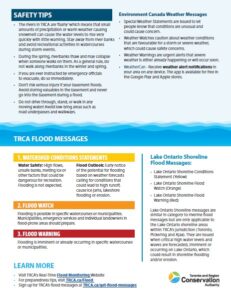
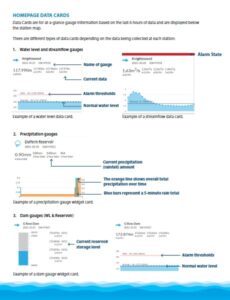
TRCA Public Resources
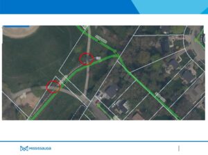
(1) Toronto and Region Conservation Authority (TRCA) has created digital flood handbooks with information to help residents understand and prepare for flooding if you live in a flood vulnerable area within TRCA’s jurisdiction. The Dixie-Dundas Digital Flood Handbook was developed to help residents and businesses understand and prepare for flooding specifically within the Dixie-Dundas Special Policy Area (SPA), within the City of Mississauga.
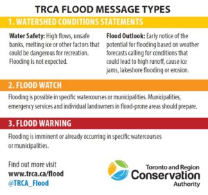
(2) TRCA operates a Flood Forecasting and Warning Program. If flooding is possible or about to occur, TRCA issues flood messages to designated individuals within municipalities, local agencies, school boards, the media, and members of the public who self-subscribe.
Location of active flood messages
- Flood messages will be posted on the TRCA homepage, on our Flood Forecasting and Warning Center webpage, and at TRCAgauging.ca.
- You can also receive flood messages directly from TRCA in two ways:
What to do if a flood message is issued
- Read the entire flood message when issued.
- Follow the safety recommendations in the action section of the flood message.
- Be prepared to follow the instructions of emergency response officials.
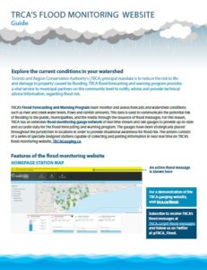
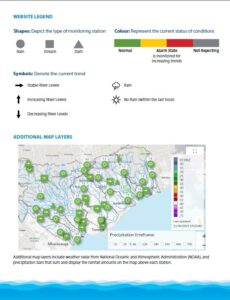
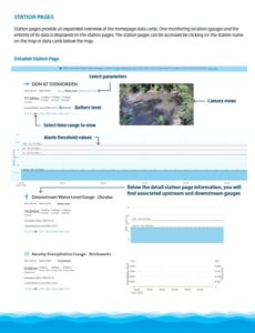
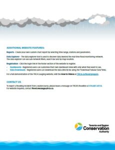
(3) As part of the Flood Forecasting and Warning Program, TRCA operates a flood monitoring gauge network spanning the GTA, which continually monitors in-stream water levels at TRCA dams and river stations as well as collecting rainfall amounts. The measurements are displayed on TRCA’s flood monitoring website. Visit the TRCA Flood Monitoring Website at trca.ca/floodmonitoring, (trcagauging.ca) and find the user guide here. Additionally, TRCA has created a series of videos designed as a user manual for the flood monitoring website. Each video includes step-by-step instructions on using different features of the site. Visit trca.ca/flood and navigate to the “Real-time Flood Monitoring in Your Neighbourhood” section to access the videos.
Nearest Gauges: Little Etobicoke at Dixie (HY098), Rathwood Precipitation Gauge (HY099)
(4) Visit the Frequently Asked Questions section for more information.
David Kellershohn, M.Eng., P.Eng.
Associate Director
Engineering Services | Development and Engineering Services
T: (437) 880-2355
C: (416) 500-9893
E: david.kellershohn@trca.ca
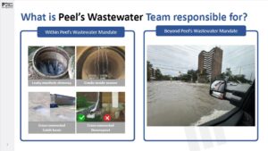
Region of Peel Wastewater Information and Resources
Link to the Region’s backwater valve program:
Peel’s wastewater by-law (peelregion.ca)


Anthony Parente, P.Eng.
General Manager – Water/Wastewater
Public Works
Region of Peel