Bird Construction Limited has been approved for the temporary road closure of Parkwest Place at Atwater Avenue to accommodate for the use of a crane for the development being constructed at the corner of Atwater Avenue and Cawthra Road. The closure will not impact access to the townhouse complex located on the eat side and the homes on the west side of Parkwest Place.
When: Monday March 24th – Wednesday March 26th, 2025
Where: Parkwest Place at Atwater Avenue
Emergency services access will not be permitted.
Exciting Update! The new website for the Port Credit Active Transportation Bridge is now live!
Explore the project details, timelines, and impacts by visiting: https://www.mississauga.ca/projects-and-strategies/city-projects/port-credit-active-transportation-bridge/
I will be sharing more updates as we get closer to breaking ground – stay tuned!
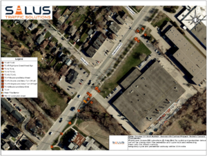
Works at the south-side of the Lakeshore Rd. E. and Haig intersection, which include the excavation and rehabilitation of the maintenance hole structure, are set to commence beginning Monday March 31, 2025.
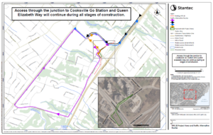
As this maintenance hole is located off the roadway, nearby to the multi-use pathway, to ensure the safety of all workers as well as the general public, the M.U.P. is to be temporarily detoured, and protected, onto the roadway as per the attached traffic control plan drawing.
This detour is to be established beginning March 24, 2025 and is anticipated to be in-place for approximately 3 weeks.
Following completion of our works at this location, the M.U.P. along with the curb-lane will be reinstated to allow the undisturbed flow of traffic (both vehicular and pedestrian).
As a part of the Lakeview Village project, a temporary road closure is being implemented for Rangeview Road at Lakefront Promenade to facilitate works related to asphalt cuts, excavation and watermain installations.
When: March 17th, 2025- March 27th, 2025
Where: Lakefront Promenade at Rangeview Road (north leg of intersection and east leg of intersection)
Advance warning signs and detour signs are in place. Emergency services access will not be permitted.
Peel Regional Police is pleased to share that we have enhanced the online Crime Occurrence Mapping Application by extending the available date range from 12 months to 36 months (3 years). This improvement allows for a more comprehensive analysis to better identify crime trends, understand community safety needs and support data-driven decision-making. By improving accessibility and transparency to crime data, we aim to empower residents, businesses, and elected officials with critical information to enhance public safety in Peel Region.
The mapping tool provides valuable insights by allowing users to view crime occurrences within their neighborhoods and across Brampton and Mississauga. Users can search by crime type, date, municipality, street name, and municipal ward. The application also includes a hotspot map layer, highlighting areas with higher concentrations of specific crime types, such as break & enters, vehicle thefts, drug trafficking, and much more.
The Crime Mapping Application can be found here: https://www.peelpolice.ca/en/in-the-community/crime-statistics-and-maps.aspx